Synopsis:
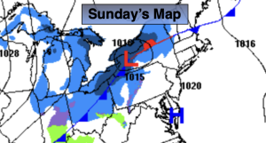
The first weekend of December will be chilly. More sun is expected for Sunday as high pressure settles along the East coast.
Another blast of Arctic air will arrive Monday with readings once again hard pressed to get above freezing. Tuesday we’ll come out of the ice box, just barely! It’ll be a better feel Wednesday as a Southwest flow of somewhat milder air works in ahead of an approaching cold front. A few showers are possible.
Thursday will be tranquil under a mix of sun and clouds.
At this time there are no major storms in the horizon. It does look to get very cold by next weekend.
Stay tuned.
Keep it here for a no nonsense, no hype forecast…
Tonight:
Becoming mostly clear. Lows around 32º in the City, the 20s inland. West winds at 5mph.
Sunday:
Partly sunny. Highs around 40º. Northwest to Southwest winds at 5-10mph.
Monday:
Partly sunny, breezy and much colder. Highs around freezing.
Tuesday:
Sunny. Highs in the mid 30s.
Wednesday:
Partly sunny. Milder. Chance of late day showers. Highs in the mid 40s.
Thursday:
Partly sunny. Highs in the mid 40s.