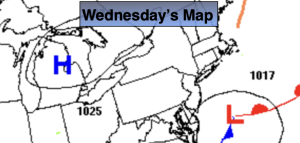
Synopsis:
Low pressure move off the coast of Maryland today. Rain or wet snow on the Northern edge of the precipitation is expected through the morning hours.. At this time no significant accumulations are expected inland. To the North it will remain dry. The precipitation will taper off later in the morning. The sun may make an appearance during the afternoon. Readings will be below average by several degrees. The average high is in the mid 50s.
High pressure will dominate the Northeast on Thursday. It’ll be bright and cool.
Milder air will move up from the South on Friday along with the chance of a few showers as low pressure moves East from the Tennessee Valley.
The weekend at this time looks bright and cool with high pressure dominating.
Stay tuned.
Keep it here for a no nonsense, no hype forecast…
Wednesday:
Morning rain (some wet snow on the Northern edge). It’ll remain dry to the North. Becoming partly sunny this afternoon. Highs around 50º. North winds at 5-10mph.
Tonight:
Partly cloudy. Lows in the upper 30s in the City, the 20s to near 30º inland. North winds at 5mph.
Thursday:
Mostly sunny. Highs around 50º.
Friday:
Mostly cloudy with scattered afternoon showers. Milder. Highs in the mid 50s.
Saturday:
Partly sunny. Highs in the lower 50s.
Sunday:
Sunny. Highs in the lower 50s.