Synopsis:
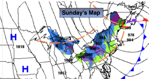
Low pressure over Eastern Maine and high pressure over the Midwest will create windy conditions for our region today. Winds will gust to 45mph at times out of the West and Northwest. Temperatures will be near the seasonal averages of the mid 50s under a party sunny sky.
These weather systems will bring down much colder air from Canada tonight into early next week. A mix of sun and clouds is expected with readings in the 40s through Tuesday.
High pressure will be along the East coast through midweek. A slow moderation in temperature is expected under partly sunny skies.
Stay tuned.
Keep it here for a no nonsense, no hype forecast…
Sunday:
Partly sunny and windy. Highs in the mid 50s. West to Northwest winds at 15-30mph with gusts to 45mph.
Tonight:
Mostly clear, breezy and cold. Lows in the mid 30s in the City, the upper 20s inland. West to Northwest winds at 15-25mph with gusts to 35mph.
Monday:
Partly sunny, windy and chilly. Highs in the mid 40s.
Tuesday:
Partly sunny. Highs in the mid to upper 40s.
Wednesday:
Mostly sunny. Highs around 50º.
Thursday:
Partly sunny. Highs around 50º.