Synopsis:
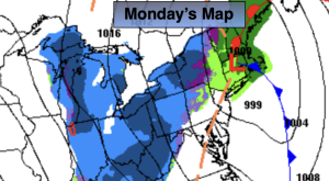
Scattered showers are in the forecast tonight through Monday morning as a cold front swings through the region. Low pressure will develop along the front and possibly prolong the threat of showers in the morning. The sun will return Monday afternoon and winds will increase out of the Northwest.
The coldest air of the season so far will arrive Monday night and Tuesday as a cold pool of air moves overhead. Readings will be near freezing along the coast Monday night with the 20s North and West. Highs will only be in the mid 40s by Tuesday with a gusty wind and the possibility of a flurry.
Winds will be busy through Much of the week with strong high pressure over the Southeast and low pressure in Eastern Canada. Readings will be several degrees below the average high of the mid 50s under a mix of clouds and sun.
Stay tuned.
Keep it here for a no nonsense, no hype forecast…
Tonight:
Mostly cloudy with scattered showers. Lows in the lower 50s in the City, the mid to upper 40s inland. South to West winds at 5-10mph.
Monday:
Scattered morning showers, otherwise, partly cloudy. Increasing winds during the afternoon. Highs in the mid 50s. West to Northwest winds at 10-20mph with gusts to 25mph.
Tuesday:
Partly cloudy, windy and colder. Scattered flurries possible. Highs in the mid 40s.
Wednesday:
Partly sunny, windy and cool. Highs in the lower 50s.
Thursday:
Partly sunny, windy and cool. Highs in the lower 50s.
Friday:
Mostly sunny and cool. Highs in the lower 50s.