Synopsis:
A mix of sun and clouds is expected for today. Readings will be seasonable in the upper 50s as high pressure moves offshore.
Showers are likely tonight with a front moving in. Spotty showers will end around sunrise Saturday. The day will feature a mix of sun and clouds with mild readings.. Another system moving in from the West will affect our weather on Sunday. Showers are possible from mid morning on. Highs will be above the average of the upper 50s.
A season changer will arrive on Monday and Tuesday with much colder temperatures. Highs will only be in the mid 40s by Tuesday!
Stay tuned.
Keep it here for a no nonsense, no hype forecast…
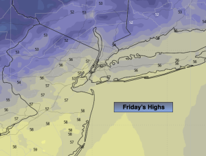
Friday:
Partly sunny. Highs in the mid to upper 50s. South winds at 10-20mph with gusts to 30mph.
Tonight:
Scattered showers. Lows in the lower 50s in the City, the 40s inland. Southwest winds 5-10mph with gusts to 20mph.
Saturday:
Clouds giving way to sun. Mild. Highs in the lower to mid 60s.
Sunday:
Cloudy with showers developing by mid morning. Highs near 60º.
Monday:
Partly sunny, breezy and cooler. Highs in the lower 50s.
Tuesday:
Mostly sunny, breezy and colder. Highs in the mid 40s.