Synopsis:
Trick or treaters need be cautious. Winds will gust between 40-50mph. Branches may snap. Secure any decorations.
November’s debut will feature a chilly breeze under a mix of sun and clouds. Readings will be near the seasonal averages of the upper 50s.
We “Fall Back” Saturday night. Daylight Saving time ends at 2am and Eastern Standard time resumes. Don’t forget to set your clock back one hour before hitting the sack. It’s also a good time to change the batteries in your smoke/carbon monoxide detectors.
Sunday will be the more tranquil day of the weekend with high pressure overhead. Sunny skies and near average temperatures are anticipated.
Sun will give way to late day showers on Monday as a cold front approaches. Temperatures will be just above average. Tuesday will be partly sunny, breezy and chilly as a Canadian airmass pays us a visit. Wednesday will feature plenty of sun and pleasant conditions.
Stay tuned.
Keep it here for a no nonsense, no hype forecast…
Tonight:
Mostly clear. Breezy. Lows in the mid 40s in the City, near 40º inland. Winds 15-30mph with gusts to 45mph in the evening.
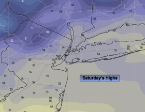
Saturday:
Partly sunny. Breezy. Highs in the upper 50s. West winds at 15-30mph.
Sunday:
Sunny. Highs in the upper 50s.
Monday:
Partly sunny. Late day showers. Highs in the lower 60s.
Tuesday:
Partly sunny, breezy and cooler. Highs in the mid 50s.
Wednesday:
Mostly sunny. Highs around 60º.