Synopsis:
Mostly sunny skies are expected through Monday as strong high pressure moves from the Ohio Valley to the Northeast. The flow will be out of Canada which equates to chilly readings. Temperatures will be below the seasonal averages of the lower 60s. Highs will remain in the 50s through the period.
On Tuesday Low pressure will be well off the Southeast coast . A mix of sun and clouds is expected. Another low will be developing over the Ohio Valley on Wednesday. Mostly cloudy skies are expected with a threat of some showers late day.
All the hype on other outlets about a Nor’easter is just that-hype. We go through this time and time again with these un-credible sources. The models are in complete disagreement with each other. There is a the potential of some rain on Thursday. Halloween at this time looks dry.
Stay tuned.
Keep it here for a no nonsense, no hype forecast.
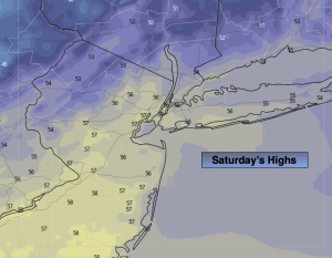
Saturday:
Sunny. Cool. Highs in the mid 50s. Northwest winds at 5-10mph.
Tonight:
Clear. Scattered frost inland. Lows in the mid 40s in the City, the 30s inland. Light winds.
Sunday:
Sunny. Highs in the mid 50s.
Monday:
Mostly Sunny. Highs in the mid 50s.
Tuesday:
Sun and clouds. Highs in the mid 50s.
Wednesday:
Mostly cloudy. Showers possible. Highs in the mid 50s.