Synopsis:
An upper level low will swing through the region today resulting in a few showers through midday. A mix of clouds and sun is expected along with breezy conditions. Highs will be near the seasonal averages of the mid 60s.
Tuesday will feature more of the same with increasing late day clouds. A few showers are possible at night.
Partly sunny skies are expected mid to late week along with a cooling trend. A Northwest wind will dominate. By Friday highs will remain only in the 50s. Stay tuned.
Keep it here for a no nonsense, no hype forecast.
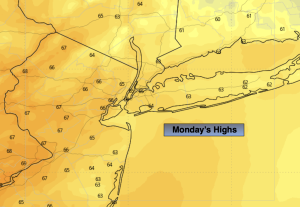
Monday:
Spotty showers through midday. Clouds and sun. Breezy. Highs in the mid 60s. West winds at 15-25mph.
Tonight:
Clear. Lows near 50º in the City, the 40s inland. West winds at 8-15mph.
Tuesday:
Party sunny. Highs in the mid 60s.
Wednesday:
Party sunny. Highs in the lower to mid 60s.
Thursday:
Party sunny. Highs around 60º.
Friday:
Sunny. Cool. Highs in the upper 50s.