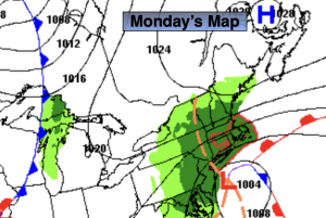
Synopsis:
The coastal storm will affect our area through today. Rain, wind and coastal flooding is expected.
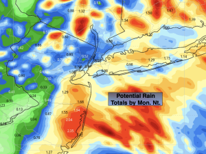
Rain will not be the big story with this storm. Potential rainfall of 1/2″ well inland to 1″-3″ at the coast is forecast by tonight.
Winds gusts will be begin to diminish along the coast through today. Gusts to 30-45mph are likely into this afternoon. Winds won’t be as strong inland.
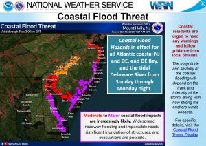
The big story is the moderate to Major coastal flooding is expected at the time of high tide through Monday. Water rises of 2′-4′ above high tide level is expected at the high tide cycles. Please take necessary precautions.
By Tuesday the storm will drift off the coast. Any morning showers will give way to some afternoon sun.
Wednesday through Friday will feature mostly sunny skies as high pressure and a brisk North wind dominate. I’ll be chilly again by late week.
Stay tuned.
Keep it here for a no nonsense, no hype forecast.
Monday:
Periods of rain. Gusty winds. Highs around 60º. Northeast winds at 15-30 gusts to 45mph at the coast.
Tonight:
Areas of rain. Diminishing in coverage. Breezy. Lows in the lower to mid 50s throughout. North/Northeast winds at 10-20mph with gusts with gusts to 30mph.
Tuesday:
Morning shower, some afternoon sun. Breezy. Highs in the lower to mid 60s.
Wednesday:
Mostly sunny. Breezy. Highs in the mid 60s.
Thursday:
Mostly sunny. Cooler. Breezy. Highs in the upper 50s.
Friday:
Sunny. Highs in the lower 60s.