Synopsis:
A change is finally on the way with an approaching cold front. Rain will develop toward midnight and continue through the morning commute. Hopefully some areas will pickup over a half an inch. We need the rain. Readings will be more seasonable. Fall will return by Thursday with highs a several degrees below the average high of the upper 60s. The sun will dominate through the end of the week.
Saturday will feature sun giving way to clouds.
We are keeping our eyes on a coastal storm for Sunday. The track is uncertain at this time. There is a low potential for some rain and wind.
Stay tuned.
Keep it here for a no nonsense, no hype forecast.
Tonight:
Thickening clouds. Rain developing toward midnight. Lows in the lower 60s throughout. Southwest winds at 5-10mph.
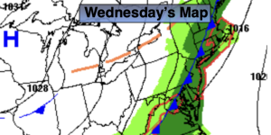
Wednesday:
Morning rain, afternoon sun. Breezy. Highs in the lower to mid 70s. Northwest winds 10-20mph.
Thursday:
Sunny. Cooler. Highs in the lower 60s.
Friday:
Sunny. Cool. Highs in the lower to mid 60s.
Saturday:
Sun to clouds. Highs in the mid 60s.
Sunday:
Chance of some rain/wind. Highs in the mid 60s.