Synopsis:
Our weather will be dominated by high pressure through Tuesday. This will result in our continuation of Summer-like temperatures. The next chance of showers will come on Wednesday with a cold front. Hopefully some areas will receive beneficial rain. Readings will be more seasonable. Fall will return by Thursday with highs a several degrees below the average high of the upper 60s. The sun will dominate through the end of the week.
Saturday will feature sun giving way to clouds.
We are keeping our eyes on a possible coastal storm for later in the weekend.
Stay tuned.
Keep it here for a no nonsense, no hype forecast.
Tonight:
Party cloudy. Lows in the lower to mid 60s in the City, the upper 50s inland. Southwest winds at 5mph.
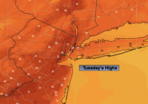
Tuesday:
Partly sunny. Warm. Highs in the lower 80s.
Wednesday:
Mostly cloudy. Scattered showers. Not as warm. Highs in the lower to mid 70s.
Thursday:
Sunny. Cooler. Highs in the lower 60s.
Friday:
Sunny. Cool. Highs in the lower 60s.
Saturday:
Sun to clouds. Highs in the mid 60s.