Synopsis:
Our weather will be dominated by high pressure through Tuesday. This will result in mainly sunny skies through the weekend and into the beginning of next week. Summer-like temperatures will be with us Sunday and into early next week as warm air moves around the backside of the high. The next chance of showers will come on Wednesday with a cold front. Readings will be more seasonable. Fall will return by Thursday with highs a few degrees below the average high of 70º.
Stay tuned.
Keep it here for a no nonsense, no hype forecast.
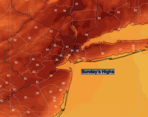
Sunday:
Sunny. Very warm. Highs in the mid 80s. Cooler at the coast. South to Southwest winds a 5-10mph.
Tonight:
Party cloudy. Lows in the lower to mid 60s in the City, the upper 40s and 50s inland. Southwest winds at 5mph.
Monday:
Sunny. Warm. Highs in the lower 80s.
Tuesday:
Partly sunny. Warm. Highs in the lower mid 80s.
Wednesday:
Mostly cloudy. Scattered showers. Not as warm. Highs in the lower to mid 70s.
Thursday:
Sunny. Cooler. Highs in the mid 60s.