Synopsis:
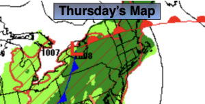
Thursday will be unsettled as an unstable airmass sits atop the region ahead of an approaching cool front. On and off rain is likely. Local downpours and a thunderstorm is possible.
On Friday the front will have pushed far enough offshore that any morning clouds should give way to some sun. It’ll be milder.
The weekend at this point looks dry with weak high pressure over the region on Saturday. A mix of sun and clouds is expected along with above average temperatures. Sunday will feature more clouds as a weak system tries to work up from the South.
The start of the week looks decent.
Stay tuned.
Keep it here for a no nonsense, no hype forecast.
Thursday:
On and off rain. Chance of a thunderstorm. Humid. Highs in the mid 70s. South winds at 8-15mph.
Tonight:
Scattered showers and storms. Lows in the mid 60s in the City, the lower 60s inland. Southwest to West winds at 5-10mph.
Friday:
Clouds to some sun. Highs in the mid to upper 70s.
Saturday:
Sun and clouds. Mild. Highs in the upper 70s.
Sunday:
Mostly cloudy. Highs in the mid 70s.
Monday:
Sun and clouds. Highs in the upper 70s.