Synopsis:
Areas of patchy morning fog, otherwise more clouds than sun is expected today. A few showers are possible as a front interacts with the region.
Thursday will be unsettled. A stationary front will be draped along the East coast. On and off rain is likely. Local downpours are possible.
On Friday the front will have pushed far enough offshore that any morning clouds should give way to some sun. It’ll be milder.
The weekend at this point looks decent with weak high pressure over the region. A mix of sun and clouds is expected along with above average temperatures.
Stay tuned.
Keep it here for a no nonsense, no hype forecast.
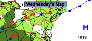
Wednesday:
Mostly cloudy. Humid. Spotty showers. Highs in the mid 70s. East winds at 5-10mph.
Tonight:
Scattered showers. Muggy. Lows in the mid 60s in the City, the lower 60s inland. East winds at 5mph.
Thursday:
Cloudy. On and off rain. Highs in the lower to mid 70s.
Friday:
Clouds to some sun. Highs in the mid to upper 70s.
Saturday:
Sun and clouds. Mild. Highs in the upper 70s.
Sunday:
Sun and clouds. Warm. Highs near 80º.