Synopsis:
High pressure off the Northeast coast will be responsible for our delightful early September weather through Thursday. Reading will be a few degrees below the average high of the lower 80s. A few showers are possible Thursday night with the passage of a weak front.
Friday and Saturday will be warmer with a mix of sun and clouds. Another chance of scattered showers or isolated storms are possible Saturday afternoon with an approaching cool front.
Sunday will be a gem with cooler readings as high pressure from the North moves in.
Stay tuned.
Keep it here for a no nonsense, no hype forecast.
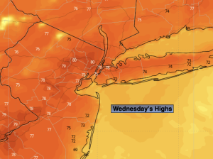
Wednesday:
Mostly sunny. Highs in upper 70s. Northeast to Southeast winds at 5-10mph.
Tonight:
Mostly clear. Lows in the mid 60s in the City, the 50s inland. South winds under 5mph.
Thursday:
Partly sunny. Highs in upper 70s.
Friday:
Mostly sunny. Warmer. Highs in the lower 80s.
Saturday:
Partly sunny. Warm. Chance of scattered afternoon showers or storms. Highs in the lower to mid 80s.
Sunday:
Mostly sunny. Cooler. Highs in the mid 70s.