Synopsis:
Today will feature a weakening front approaching from the West and Low pressure scooting off the Carolina coast. These features will result in a few more clouds and more humid conditions for the second half of the weekend. An isolated shower can’t be ruled out over the Northwest section of the state. This won’t hamper any outdoor plans.
Spotty showers are possible Sunday night and Monday morning with the passage of the weak cool front. It’ll still be warm Monday with highs in the 80s.
High pressure over the Midwest will result in a Northwest flow out of Canada through midweek. Temperatures will be cooler than average with abundant sunshine. You can’t ask for better weather in later August!
Stay tuned.
Keep it here for a no nonsense, no hype forecast…
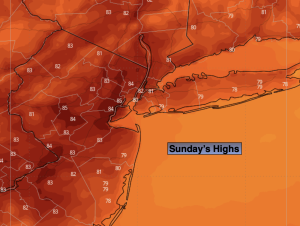
Sunday:
Party sunny. Chance of isolated afternoon showers North and West. Highs in the lower 80s. South winds at 5-10mph.
Tonight:
Mostly cloudy. Spotty showers possible. Lows in the upper 60s in the City, the lower 60s inland. Light winds.
Monday:
Sun and clouds. Isolated morning showers. Warm. Highs in the mid 80s.
Tuesday:
Mostly sunny. Cooler. Highs in the upper 70s to around 80º.
Wednesday:
Sunny. Pleasant. Highs in the mid to upper 70s.
Thursday:
Sunny. Pleasant. Highs in the upper 70s.