Synopsis:
Today will feature abundant sun and warm readings as high pressure settles over the region. The humidity will be in check. A spectacular day indeed.
A mix of sun and clouds is expected for Sunday and Monday. A few showers are possible with an approaching front. It’ll remain warm and much of the time will be dry.
High pressure over the Midwest will result in a Northwest flow out of Canada through midweek. Temperatures will be cooler than average with abundant sunshine. You can’t ask for better weather in later August!
Stay tuned.
Keep it here for a no nonsense, no hype forecast…
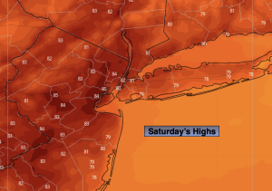
Saturday:
Sunny. Warm. Highs in the lower to mid 80s. Southwest winds at 5-10mph.
Tonight:
Partly cloudy. Lows in the upper 60s in the City, the lower 60s inland. South winds at 5mph.
Sunday:
Party sunny. Chance of isolated afternoon showers. Highs in the lower to mid 80s.
Monday:
Sun and clouds. Spotty showers. Highs in the lower to mid 80s.
Tuesday:
Mostly sunny. Cooler. Highs in the upper 70s.
Wednesday:
Sunny. Pleasant. Highs in the mid to upper 70s.