Synopsis:
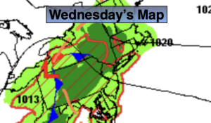
A cool front will approach the area on Wednesday. More clouds are expected with scattered showers possible just about anytime. It won’t be a washout. It’ll be cool.
Hurricane Erin will pass off the East coast Thursday and make its closest approach to our region. A few showers are possible with the cool front moving to our South in the morning. It’ll be breezy with the combination of the circulation of Erin offshore and high pressure to the North. High surf and dangerous rip currents will occur. Please do not go in the ocean through late week. Heed the warnings of life guards.
Friday and Saturday will feature abundant sun and warm readings as high pressure settles over the region.
A mix of sun and clouds is expected for Sunday. A few showers are possible with an approaching front. It’ll remain warm.
Stay tuned.
Keep it here for a no nonsense, no hype forecast…
Tonight:
Mostly cloudy. Lows in the 60s throughout. East to Southeast winds at 8-12mph.
Wednesday:
Mostly cloudy. Scattered showers. Cool. Highs in the lower 70s. East to Northeast winds at 10-20mph.
Thursday:
Scattered morning showers, afternoon sun. Breezy. Highs in the mid 70s.
Friday:
Sunny. Warmer. Highs in the lower 80s.
Saturday:
Sunny. Highs in the lower 80s.
Sunday:
Party sunny. Chance of scattered afternoon showers. Highs in the lower 80s.