Synopsis:
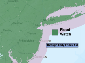
It will be humid today but not as hot as recent days. A cool front will move toward the region. Low pressure will develop along the front. This will result in scattered showers and storms. Some of the storms will contain torrential rain. A Flood Watch has been issued for the entire area. Some areas may pick up several inches of rain, while other areas will receive much less. Please, never drive through flooded roadways. You don’t know how deep that water is-TURN AROUND, DON’T DROWN.
Scattered showers will continue overnight into early Friday morning as the front pushes offshore. It’ll feel like a different season on Friday with much cooler conditions and low humidity. A well deserved break! Some sun will shine later in the day.
Strong high pressure over the Great Lakes will provide the region with a delightful weekend. Abundant sunshine, low humidity and pleasant readings can be expected.
Stay tuned.
Keep it here for a no nonsense, no hype forecast…
Thursday:
Becoming mostly cloudy with scattered showers and storms developing from North to South during the day. Torrential rain possible in spots. Very humid, but not as hot. Highs in the mid 80s. Northeast winds at 8-12mph.
Tonight:
Early scattered storms with areas of torrential rain. Scattered showers late. Much less humid. Lows in the 60s throughout. Breezy. Northeast winds at 10-20mph.
Friday:
Early morning showers East, otherwise clouds giving way to some afternoon sun. Much cooler. Highs only in the mid 70s.
Saturday:
Sunny, breezy and pleasant. Highs around 80º.
Sunday:
Sunny. Pleasant. Highs in the lower to mid 80s.
Monday:
Mostly sunny. Highs in the mid 80s.