Synopsis:
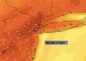
High pressure along with a bubble of warm air will translate into a Summer-like start to the week. Readings will be near 80º both today and Tuesday. The record high for today for Central Park and Newark is 84º. Both days will feature abundant sunshine.
Wednesday will be mild ahead of a cool front. The front will come through moisture starved Wednesday night. Thursday will be more seasonable with readings in the lower 60s. It’ll be a cool, bright end to the week as high pressure moves in from the Northwest.
Our stretch with no rain for the month of October continues. There is no rain in the foreseeable future and these drought conditions will only worsen. Conserve water and please use caution outdoors with flammables.
Stay tuned.
Keep it here for a no nonsense, no hype forecast.
Monday:
Sunny. Warm. Highs around 80º. West to Southwest winds at 5-10mph.
Tonight:
Clear. Mild. Lows in the lower 60s in the City (this is near the average high of the date!), the 40s & 50s inland. Light West winds.
Tuesday:
Sunny. Warm. Highs around 80º.
Wednesday:
Mostly sunny. Mild. Highs in the mid 70s.
Thursday:
Mostly sunny. More seasonable. Highs in the lower 60s.
Friday:
Mostly sunny. Highs in the lower 60s.