Synopsis:
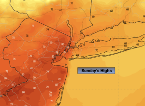
Partly sunny, warm conditions are expected for Sunday for most of the area. A warm front should push to our North allowing for more sun and much warmer temperatures. Over extreme Northern NJ the front won’t make it through keeping this will result in much cooler temperatures. Spotty showers are possible in this area. . Highs will be nearly ten degrees above the average high of the upper 60s. It will feel more like early September rather than mid October, the exception being to the North.
Temperature will go down in a hurry early next week as a shot of chilly air works in from the North. Monday may feature a spot shower in the morning. A potent cold front will work through by midday accompanied by increasing winds during the afternoon with readings several degrees below average.
Midweek will be chilly and blustery. Winds will be busy out of the Northwest creating a definite nip in the air.
Stay tuned.
Keep it here for a no nonsense, no hype forecast.
Sunday:
Sun and clouds. Warm. Highs in the upper 70s. Much cooler over extreme Northern NJ. South to Southwest winds at 5-15mph.
Tonight:
Partly cloudy. Spot shower. Lows in the 50s throughout. Southwest to Northwest at 5-10mph.
Monday:
Partly sunny. Spot morning shower possible. Cooler. Highs in the lower 60s.
Tuesday:
Partly sunny, windy and much cooler. Highs in the mid 50s.
Wednesday:
Mostly sunny. Chilly. Highs in the mid 50s.
Thursday:
Sunny. Cool. Highs in the lower 60s.