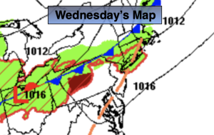
Synopsis:
A hot push of air will arrive today. Readings will get into the 90s and humidity levels will be high. The heat index will approach 100º along the urban corridor. Heat Advisories have been posted. A few storms will develop later in the day and evening as a cool front approaches. The greatest chance for storms to occur will be South and West of the City. Some of these storms may turn severe. Keep an eye to the sky for threatening weather after 4pm in this area.
This front will be a season changer. On Thursday and Friday High pressure from Canada will bring down much cooler and drier air! A mix of clouds and sun is expected.
The beginning of the Labor Day Weekend has a few concerns. Saturday will feature an approaching cool front. The latest computer guidance has the day dry under hazy sun. Scattered showers and storms are possible toward evening. The front may take its sweet ol’ time moving offshore on Sunday. Showers are now possible in the morning. Conditions should improve during the afternoon with the sun making a comeback. Labor Day will be a winner as strong high pressure over the Great Lakes brings in a refreshing airmass. Abundant sunshine and cooler temperatures are anticipated.
Stay tuned.
Keep it here for a no nonsense, no hype forecast.
Wednesday:
Hazy, hot and humid. Scattered late day and evening storms mainly South and West of the City. Highs in the lower to mid 90s. Heat index around 100º. Southwest to Northwest winds at 8-12mph.
Tonight:
Scattered storms mainly South early, otherwise partly cloudy. Cooler and less humid by morning. Lows in the mid 60s in the City, the lower 60s inland. Northeast winds at 8-12mph.
Thursday:
Sun and clouds. Much cooler. Highs in the mid 70s.
Friday:
Sun and clouds. Pleasant. Highs in the mid 70s.
Saturday:
Hazy sun and clouds. More humid. Scattered late day and evening showers and storms. Highs in the lower 80s.
Sunday:
Morning showers possible. Skies should become partly sunny during the afternoon. Highs in the lower 80s.