
Synopsis:
A Western Atlantic high (Bermuda High) will continue to influence our area. This setup will result in high temperatures and humidity. The 90s will once again greet us. Intense heat is likely Tuesday and Wednesday. The heat index will approach 110º in some regions. This will become our third heatwave of the season. The only relief will be along the immediate coast. The thunderstorm threat will be Monday and Wednesday afternoon (scattered in nature).
Relief from the heat and humidity will arrive on Thursday with an early morning cool frontal passage. Readings will be near average (the mid 80s) and humidity levels will be much lower. The fine July conditions will continue into Friday.
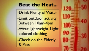
Please remember to check on the pets and elderly during this hot stretch. Drink plenty of fluids and try to stay out of the direct sun between 10am-4pm. Wear light weight, light colored clothing.
Stay tuned.
Keep it here for a no nonsense, no hype forecast.
Monday:
Hazy, hot and humid. Chance of an afternoon storm. Highs in the lower to mid 90s. Heat index: 95º-100º. Southwest winds at 8-12mph.
Tonight:
An evening scattered storm, otherwise partly cloudy and muggy. Lows in the mid to upper 70s in the City, near 70º inland. Southwest winds at 5mph or less.
Tuesday:
Hazy, hot and humid. Highs in the mid to upper 90s. Heat index: 100º-110º.
Wednesday:
HHH. Spotty PM Storms. Highs in the mid 90s. Heat index: 100º-110º.
Thursday:
Partly sunny, cooler and less humid. Highs in the mid 80s.
Friday:
Sunny. Highs in the mid 80s.