Synopsis:
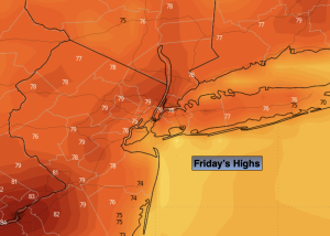
High pressure to our North will result in a fine finish to the week. Abundant sunshine with readings below average (average high is 84º) are expected. It will be a delightful Friday.
The weekend will be half way decent. The humidity will increase on Saturday with the flow around a departing Atlantic high. Readings will be near seasonable levels under a mix of clouds and sun. A cool front will slowly approach the region and stall near the area on Saturday night and Sunday. Scattered showers and storms are possible Saturday night. Ahead of the front on Sunday it’ll be hazy, hot and humid. Scattered thunderstorms are possible just about anytime. It will not be a washout.
A couple of gems are on the way for Monday and Tuesday as high pressure builds into the region from the West. Temperatures will be near average. The sun will dominate both days.
Stay tuned.
Keep it here for a no nonsense, no hype forecast.
Friday:
Sunny. Highs around 80. Northeast to Southeast winds at 5-10mph.
Tonight:
Partly cloudy. Lows in the mid 60s in the City, the 50s inland. Southeast winds 5mph.
Saturday:
Clouds and sun. Becoming more humid. Highs in the mid 80s.
Sunday:
Hazy, hot and humid. Scattered thunderstorms possible just about anytime. Highs in the lower 90s.
Monday:
Mostly sunny, cooler and much less humid. Highs in the lower to mid 80s.
Tuesday:
Sunny. Highs in the mid 80s.