Synopsis:
The break in the heat will be short-lived as high pressure moves offshore today and Wednesday. This will allow a bubble of heat to work in. Tuesday will not be humid; it will be a dry heat accompanied by abundant sunshine. Wednesday will be a different story with rising humidity levels and hazy skies. Showers and storms are likely with an approaching cool front later Wednesday. More comfortable air will work in from the North behind the front for Thursday and Friday.
The weather should cooperate for the beginning of the weekend.
Stay tuned.
Keep it here for a no nonsense, no hype forecast.
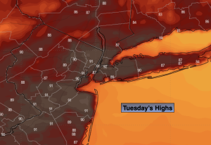
Tuesday:
Sunny. Hot. Highs in the lower 90s. West to Southwest winds at 8-15mph.
Tonight:
Clear. Lows in the lower 70s in the City, the 60s inland. Northwest winds at 5-10mph
Wednesday:
Hazy, hot and humid. Chance of afternoon and evening storms. Highs in the mid 90s.
Thursday:
Partly sunny. Cooler and less humid. Highs in the mid 80s.
Friday:
Sunny. Highs around 80.
Saturday:
Sun and clouds. Highs in the mid 80s.