Synopsis:
Relief will arrive today as a gusty Northwest wind brings in more comfortable air- finally!
The break in the heat will be short-lived as high pressure moves offshore on Tuesday and Wednesday. This will allow a bubble of heat to work in. Showers and storms are likely with an approaching cool front later Wednesday. Once again, cooler air will work in from the North behind the front for Thursday and Friday.
Stay tuned.
Keep it here for a no nonsense, no hype forecast.
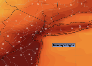
Monday:
Partly sunny, cooler and much less humid. Highs in the mid 80s. Northwest winds 15-25mph.
Tonight:
Clear and comfortable. Lows in the mid 60s in the City, the 50s inland. Northwest winds at 8-12mph.
Tuesday:
Sunny. Hot. Highs around 90º.
Wednesday:
Hazy, hot and humid. Chance of afternoon storms. Highs in the mid 90s.
Thursday:
Partly sunny. Cooler and less humid. Highs in the mid 80s.
Friday:
Sunny. Highs around 80.