Synopsis:
A disturbance will move through the region this morning with scattered showers and a possible storm. The sun will return shortly after and readings will skyrocket to July levels as a bubble of warm area is located over the Mid-Atlantic.
On Thursday, temperatures will begin their downward trend. The combination of a front to our South and the flow off the ocean will result in any sun giving way to thickening clouds. Showers will move in during the afternoon.
A weak low will move through the region on Friday. It’ll be chilly with on and off showers.
By Saturday, enough drier air will work in from the West to allow for a mix of sun and clouds. Temperatures will be several degrees below average.
The Mother’s Day forecast is an unsettled one. Another weak low will move through the region from the West. Scattered showers are in the forecast. I will work on changing this one, fingers crossed.
Stay tuned.
Keep it here for a no nonsense, no hype forecast.
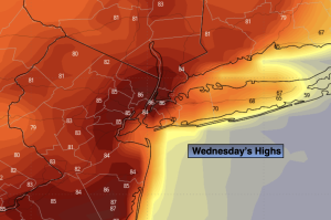
Wednesday:
AM spotty showers and storms. Becoming partly sunny. Very warm. Highs in the mid 80s. Cooler over parts of Long Island. Southwest to West winds at 8-15mph.
Tonight:
Partly cloudy. Lows in the lower 60s in the City, the 50s inland. West to Northwest winds 5mph.
Thursday:
Any sun giving way to clouds. Showers developing during the afternoon. Cooler. Highs around 70º.
Friday:
Scattered showers. Cool. Highs in the upper 50s.
Saturday:
Partly sunny. Highs in the mid 60s.
Mother’s Day:
Mostly cloudy. Chance of showers. Highs in the lower to mid 60s.