Synopsis:
Clouds and fog will give way to sun on Monday. Readings will pop to almost twenty degrees higher than they were on Sunday. Our rollercoaster ride in temperature continues.
A winner is expected for Tuesday with readings almost ten degrees above the average high of the upper 60s.
A weak low will move through the region on Wednesday. More clouds than sun is expected. Scattered showers and isolated storms are possible. It will be warm.
On Thursday, high pressure off the Northeastern coast will result in a wind off the colder Atlantic. This combined with a weak disturbance to our South will result in rain and much cooler readings.
The weak low will eventually move off the coast on Friday. A few showers are likely with a mix of clouds and sun.
Stay tuned.
Keep it here for a no nonsense, no hype forecast.
Monday:
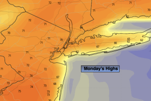
Morning patchy fog and clouds to breaks of sun. Milder. An isolated shower is possible. Highs in the lower to mid 70s. Southeast to West winds at 5mph.
Tonight:
Partly cloudy. Lows around 60º in the City, near 50º inland. Southwest to North winds less than 5mph.
Tuesday:
Mostly sunny. Warmer. Highs around 80º.
Wednesday:
Mostly cloudy. Warm. Scattered showers and isolated storms. Highs around 80º.
Thursday:
Rain likely. Much cooler. Highs in the mid 60s.
Friday:
Clouds and sun. Spotty showers.. Highs in the upper 60s.