Synopsis:
Welcome to May, and a nice start to the new month it will be. Any morning clouds and fog will give way to partly sunny skies and warmer readings as weak high pressure influences the area.
High pressure will build off the Southeast coast on Thursday. This will result in a warm push of air from the South and West. Readings will pop into the 80s. The average high is in the upper 60s.
It’ll be a nice close to the workweek with more seasonable readings and bright skies.
Saturday will feature increasing clouds as high pressure loses its influence along the East coast. It’ll be cooler with a marine influence.
Grab the umbrella for Sunday. Showers are expected with a disturbance moving over the area from the West.
Stay tuned.
Keep it here for a no nonsense, no hype forecast.
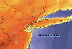
Wednesday:
Clouds to sun. Warmer. Highs in the mid 70s, cooler at the coast. Northeast to Southeast winds at 5mph.
Tonight:
Partly cloudy. Lows in the 50s throughout. Light Southeast winds.
Thursday:
Mostly sunny. Warmer. Highs in the lower to mid 80s.
Friday:
Mostly sunny. Seasonable. Highs in the upper 60s.
Saturday:
Sun to clouds. Cooler. Highs in the lower to mid 60s.
Sunday:
Scattered showers. Cool. Highs in the upper 50s.