Synopsis:
Weak low pressure will move off the coast this morning. Scattered showers will taper off. The sun may make an appearance later in the day. It’ll be mild with readings several degrees above the average high of 43º.
Colder air will filter in from Eastern Canada on Saturday as high pressure builds in from the West. Skies will at least be bright. Sunday will be sunny with readings moderating to near average.
A mild Monday will kick off the new week as a Southerly flow begins to take shape. This Spring feel will continue into the middle of next week!
Stay tuned.
Keep it here for a no nonsense, no hype forecast..
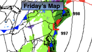
Friday:
Showers will taper off this morning. Some late day sun is possible. Highs near 50º. Winds becoming Northwest at 5-10mph.
Tonight:
Clear. Lows 30º-35º. West winds 10-15mph.
Saturday:
Mostly sunny, breezy and colder. Highs in the mid to upper 30s.
Sunday:
Sunny. Seasonable. Highs in the lower 40s.
Monday:
Partly sunny. Mild. Highs in the lower to mid 50s.
Tuesday:
Partly sunny. Mild. Highs in the mid 50s.