Synopsis
A tranquil weather pattern will be with us through the next five days. Seasonable temperatures are expected for today and Wednesday as high pressure sits over the Northeast. Clouds will dominate both days with the flow off the ocean. Flurries and or sprinkles are possible later today, tonight and into Wednesday morning.
We’ll go above average with the mercury on Thursday as the lack of Arctic air continues as we turn the page to February. On Friday, Groundhog Day, a cold front will approach. A shower is possible in the morning, otherwise skies will be partly sunny with readings still above the average highs of the upper 30s. More seasonable conditions are expected for Saturday as colder high pressure to the North filters in. Abundant sunshine is expected. There are no storms in sight. A dismal outlook for snow lovers.
Stay tuned.
Keep it here for a no nonsense, no hype forecast.
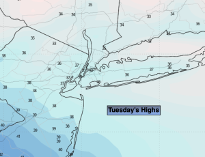
Tuesday:
More clouds than sun. Scattered flurries possible later in the day. Highs in the upper 30s. North to East winds at 5-10mph.
Tonight:
Cloudy with scattered flurries possible. Lows near freezing in the City, the 20s inland. East to Southeast winds at 5mph.
Wednesday:
Mostly cloudy with scattered morning flurries possible. Highs in the upper 30s.
Thursday:
Partly sunny. Highs in the mid 40s.
Friday:
Clouds and sun. Spot AM shower. Highs in the mid 40s.
Saturday:
Sunny. Seasonable. Highs in the upper 30s.