Synopsis
Low pressure will continue to move out to sea and intensify today. A few rain or snow showers are possible this morning, otherwise the sun may make an appearance from time to time. There’ll be a gusty North wind.
Most areas tonight will be at or below freezing as colder air works in from the North.
Seasonable temperatures are expected for Tuesday and Wednesday as high pressure sits over the region. The sun will dominate. We’ll go above average with the mercury on Thursday as the lack of Arctic air continues as we turn the page to February. On Friday, Groundhog Day, a cold front will approach. Scattered rain or snow showers are possible. Much of the time it will be dry.
Keep it here for a no nonsense, no hype forecast.
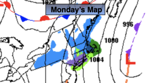
Monday:
Morning scattered rain and or snow showers. Few peeks of sun. Breezy. Highs in the lower 40s. North winds at 10-20mph.
Tonight:
Mostly cloudy. Lows near freezing in the City, the 20s inland. North winds diminishing to 5-10mph.
Tuesday:
Partly sunny. Highs in the upper 30s.
Wednesday:
Mostly sunny. Highs in the upper 30s.
Thursday:
Partly sunny. Highs in the mid 40s.
Friday:
Clouds and sun. Scattered rain or snow showers. Highs in the lower 40s.