Synopsis
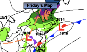
Areas of morning showers, drizzle and fog will give way to a drier afternoon as low pressure weakens and moves off the coast. If enough dry air works in a bit of sun may shine by late day. Readings will be several degrees above the average high of 38º.
There’ll be a brief break in the action on Saturday as high pressure builds over our region. Any sunshine will give way to afternoon clouds as the January thaw continues.
Another area of low pressure will develop over the Tennessee Valley on Sunday and move to off the Mid-Atlantic coast by late day. This will bring another round of rain. The rain has a potential to change over to wet snow late day Sunday North and West of the City as cold air gets wrapped into the system. There is only marginally cold air available and no true influx of Canadian air with high pressure to the North. For this reason the City and coast should be predominantly rain. As the low intensifies South of Long Island the rain may end as scattered flurries at the coast Monday morning. There is a potential of some accumulation North and West by Monday morning. Just how much is yet to be determined. Stay tuned. The sun should return Monday afternoon accompanied by a gusty North wind.
Seasonable temperatures are expected for Tuesday as high pressure sits over the region. The sun will dominate.
Keep it here for a no nonsense, no hype forecast.
Friday:
Areas of morning drizzle, showers and fog. Some breaks of late afternoon sun possible. Highs in the mid 40s. North/Northeast winds at 5mph.
Tonight:
Mostly cloudy. Lows around 40 in the City, the 30s inland. Light and variable winds.
Saturday:
More clouds than sun. Highs in the mid 40s.
Sunday:
Rain. Rain may change to wet snow North and West by late day. Highs around 40º.
Monday:
Morning flurries. Becoming partly sunny. Breezy. Highs in the mid to upper 30s.
Tuesday:
Partly sunny. Highs in the upper 30s.