Synopsis
On and off rain is likely today and tonight with a disturbance moving along a stationary front. It will be mild. Temperatures will be at least fifteen degrees above the average high of the upper 30s.
Early morning showers on Friday will move offshore with a passing front. Skies will become partly sunny. Reading will still be several degrees above average.
There’ll be a brief break in the action on Saturday as high pressure builds over our region. Sunshine will give way to afternoon clouds as the January thaw continues.
Another area of low pressure will develop over the Tennessee Valley on Sunday and move to off the Mid-Atlantic coast by late day. This will bring another round of rain. The rain has a low potential to change over to snow Sunday night and Monday morning as cold air gets wrapped into the system. The greatest chance of this happening is over inland areas. This is a low potential for the City and the coast. Any rain or snow will end Monday midday. Stay tuned.
Keep it here for a no nonsense, no hype forecast.
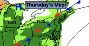
Thursday:
On and off rain. Milder. Highs in the mid 50s. Southwest to North winds at 5mph.
Tonight:
On and off rain. Lows in the mid 40s in the City, the upper 30s inland. Northeast winds at 5-10mph.
Friday:
Early morning showers, otherwise becoming partly sunny. Highs in the upper 40s.
Saturday:
Sun to clouds. Mild. Highs in the upper 40s.
Sunday:
Rain. Highs around 40º.
Monday:
Snow or rain ending around midday. Highs in the mid 30s.