Synopsis
A frontal boundary will remain near our area through Friday morning. Disturbances will be riding along this boundary resulting in times of showers and periods of rain.
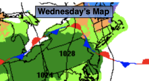
Today temperatures should get to above average (the upper 30s) as the wind shifts to the Southeast. Spotty showers are in the forecast but much of the time it will be dry. Steadier showers will work in toward sunset.
Rain is likely tonight and Thursday as a stronger disturbance move along the front. Temperatures will continue their upward trend.
Early morning showers on Friday will move offshore with a passing front. Skies will become partly sunny and there’ll be a Spring feel in the air .
There’ll be a brief break in the action on Saturday as high pressure builds over our region. Sunshine will give way to afternoon clouds as the January thaw continues.
Another area of low pressure will develop over the Tennessee Valley on Sunday and move to off the NJ coast by late day. This will bring another round of rain. A lot will have to change for any of this precipitation to be snow for the second half of the event. Impossible no, unlikely yes.
Keep it here for a no nonsense, no hype forecast.
Wednesday:
Mostly cloudy. Spotty showers. Highs in the mid 40s. Light East to Southeast winds at 5mph.
Tonight:
Rain developing. Lows in the mid 40s along the urban corridor, the 30s to around 40º inland. Southeast to Southwest winds at 5-10mph.
Thursday:
Rain likely. Milder. Highs around 50º.
Friday:
Early morning showers, otherwise becoming partly sunny. Balmy. Highs in the upper 50s.
Saturday:
Sun to clouds. Mild. Highs in the upper 40s.
Sunday:
Rain. Highs in the mid 40s.