Synopsis
A frontal boundary will remain near our area through Friday morning. Disturbances will be riding along this boundary resulting in times of showers, rain and a light mix North.
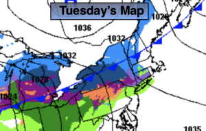
It will be cold enough that a bit of light snow and or a mix will occur mainly to the North and West of the City today. It will be scattered. Along the urban corridor mainly showers are expected. The precipitation won’t be that heavy but slick spots are possible where surfaces are untreated. To the South of the City it should remain mainly dry as the focus will be over the Northern 1/2 of the NYC tri-state area. Readings will be near the seasonable averages of the upper 30s, but closer to freezing well North.
Wednesday temperatures should get to above average as the wind shifts to the South. Scattered showers are in the forecast.
Rain is likely Thursday as a stronger disturbance move along the front. Temperatures will continue their upward trend.
Showers are likely Friday morning as a front moves offshore. Skies will become partly sunny and there’ll be a Spring feel in the air .
There’ll be a brief break in the action on Saturday as high pressure builds over our region. Mainly sunny skies are expected and the January thaw will continue.
Keep it here for a no nonsense, no hype forecast.
Tuesday:
Scattered light mix North and West. Spotty showers elsewhere with the exception of Central and Southern NJ- It’ll remain just cloudy. Highs in the mid to upper 30s, near freezing inland. West to North winds at 5mph.
Tonight:
Scattered light mix North and West. Few showers elsewhere. Lows in the mid 30s along the urban corridor, around 30º inland. Light Northeast wind.
Wednesday:
Mostly cloudy. Scattered showers. Highs in the mid 40s.
Thursday:
Rain likely. Milder. Highs around 50º.
Friday:
Morning showers, otherwise becoming partly sunny. Balmy. Highs in the upper 50s.
Saturday:
Mostly sunny. Mild. Highs in the lower 50s.