Synopsis
We’ll be out of the freezer today as strong high pressure moves off the coast and a milder flow takes hold.
Tuesday will feel like a heatwave as we get into the 40s under mostly cloudy skies. Afternoon showers are possible.
It’ll be mild on Wednesday and Thursday with scattered showers as disturbances move in from the West.
An early morning shower on Friday as a front moves offshore. Skies will become partly sunny and there’ll be a Spring feel in the air .
Keep it here for a no nonsense, no hype forecast.
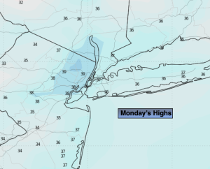
Monday:
Mostly sunny. Milder. Highs in the 30s to around 40º. West to Southwest winds at 8-12mph.
Tonight:
Mostly cloudy. Not as cold as recent nights. Lows around freezing along the urban corridor, the upper 20s inland. West to Southwest winds at 5-10mph.
Tuesday:
Mostly cloudy. Mild. A spot afternoon shower possible. Highs in the lower to mid 40s.
Wednesday:
Mostly cloudy. Scattered showers. Highs in the mid 40s.
Thursday:
Mostly cloudy. Milder. Scattered showers. Highs around 50º.
Friday:
A morning shower, otherwise becoming partly sunny. Balmy. Highs in the upper 50s.