Synopsis
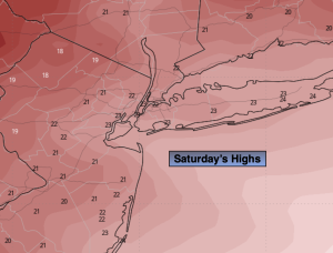
Saturday will be frigid despite plenty sunshine as a large cold dome of high pressure dominates the Eastern US. The wind will add a bite as winds chills will remain in the teens along the coast to around 10º well inland.
It’ll be bitterly cold tonight under partly cloudy skies with a gusty wind. Wind chills will be near 0º inland the single digits at the coast.
Sunday readings under sunny skies will remain below freezing the wind will still make a presence.
We’ll be out of the freezer on Monday as the high moves off the coast and a milder flow takes hold.
Tuesday will feel like a heatwave as we getting into the 40s!
It’ll be mild on Wednesday with scattered showers as a disturbance moves in from the West.
Keep it here for a no nonsense, no hype forecast.
Saturday:
Partly sunny, breezy and frigid. Highs in the 20s. Northwest winds at 15-25mph with gusts to 30mph. Wind chills in the teens near 10º inland.
Tonight:
Partly cloudy and bitterly cold. Lows in the upper teens along the urban corridor, the lower to mid teens inland. Northwest winds at 10-20mph with gusts to 25mph. Wind chills in the single digits to near zero inland.
Sunday:
Sunny. Highs around 30º.
Monday:
Sunny. Highs in the upper 30s.
Tuesday:
Sun to clouds. Mild. Highs in the mid 40s.
Wednesday:
Mostly cloudy. Scattered showers. Highs in the mid 40s.