
Synopsis:
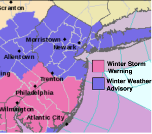
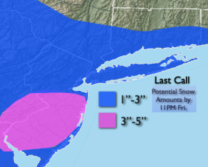
Many ingredients will come together today for some Snow. Low pressure will develop offshore. A surface trough will develop and enhance snowfall over parts of the area to the South of the City. At the same time the jet stream will sharpen over the Northeast. This may result in some banding to the snow. All of these features including where the trough sets up (axis of best convergence) will determine where the maximum snowfall occurs. At this time it looks like Central and Southern NJ will be the bullseye- a 3″-5″ band has been added. I also have to state this area has the highest bust potential if the ingredients don’t come together. Areas well to the North may see little in the way of any accumulation. This region will have much drier air and be farthest away from the moisture source. The light snow will start Friday morning between 6-10am and continue throughout the day. There will be several hours of steadier snow by midday and early afternoon. The snow will taper off from North to South later in the afternoon and evening.
Saturday will be frigid as an Arctic blast makes a visit. Readings will only be in the 20s. The windchills will be quite low.
Sunday readings under abundant sunshine will remain below freezing.
We’ll be out of the freezer on Monday as the high moves off the coast and a milder flow takes hold.
Tuesday will feel like a heatwave as we getting into the 40s!
Keep it here for a no nonsense, no hype forecast.
Friday:
Snow likely. Highs around 30º. Northeast to North at 8-12mph.
Tonight:
Becoming mostly clear, breezy and much colder. Lows in the upper teens along the urban corridor, the lower to mid teens inland. Northwest winds at 10-20mph.
Saturday:
Partly sunny, windy and frigid. Highs in the 20s.
Sunday:
Sunny. Highs in the upper 20s.
Monday:
Sunny. Highs in the upper 30s.
Tuesday:
Sun to clouds. Mild. Highs in the lower 40s.