
Synopsis:
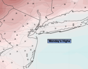
The Reverend Dr. Martin Luther King Jr. Day will be cold with highs near freezing. Clouds will roll in during the afternoon.
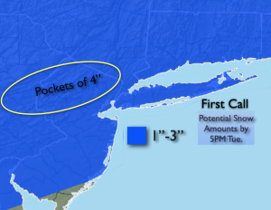
Light snow will develop from Southwest to Northeast this evening from 8pm to 11pm as a swath of snow moves up from the South. A low will develop off the Mid-Atlantic and move Northeast Tuesday. The latest computer has the low closer to the coast with slightly heavier precipitation amounts. For this reason, I may be upping the potential snow graphic amounts slightly. Maybe more of a 2″-4″ for much of the region. A mix to sleet and freezing rain is possible as well. The precipitation may end over Southern sections later in the morning. Most areas will see the snow or mix end during the mid afternoon time frame.
Wednesday and Thursday will feature partly sunny skies and cold temperatures as high pressure over the Southeast dominates our weather . Highs will be around freezing.
On Friday, a storm will develop off the coast. Many of the computer models are showing a bit of snow over the region. At this time there is a low potential of accumulating snow. I am hedging toward the light side. Stay tuned.
Keep it here for a no nonsense, no hype forecast.
MLK Day:
Sun to afternoon clouds. Cold. Highs in the lower 30s. West 5-1omph.
Tonight:
Snow developing this evening and continuing overnight. Lows in the 20s throughout. West to Northeast at 5mph.
Tuesday:
Snow, possible mix. Highs around freezing.
Wednesday:
Partly sunny. Cold. Highs in the upper 20s.
Thursday:
Partly sunny. Highs around freezing.
Friday:
Low snow potential. Highs around 30º.