Synopsis:
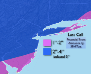
Light snow will develop from Southwest to Northeast this evening from 7pm to 11pm as a swath of snow moves up from the South. A low will develop off the Mid-Atlantic and move Northeast Tuesday. The latest computer guidance has the low closer to the coast with slightly heavier precipitation amounts. For this reason a 2″-4″ snowfall is expected for much of the region. A mix to sleet and freezing rain is possible as well on Tuesday. The precipitation may end over Southern sections by mid morning. Most areas will see the snow or mix end during the mid afternoon time frame. Temperatures will hover around freezing on Tuesday.
Wednesday and Thursday will feature partly sunny skies and cold temperatures as high pressure over the Southeast dominates our weather. Readings will be at or below the 32º mark.
On Friday, a storm will develop off the coast. Many of the computer models are showing a bit of snow over the region. At this time there is a low potential of accumulating snow. I am leaning toward the light side. Still a few days to see how this all plays out.
Saturday will be frigid as an Arctic blast makes a visit. Readings will only be in the 20s.
Keep it here for a no nonsense, no hype forecast.
Tonight:
Snow developing this evening and continuing overnight. Lows in the 20s throughout. West to Northeast at 5mph.
Tuesday:
Snow, possible mix. Ending in the South during the morning, elsewhere during the afternoon. Highs around freezing. Northeast to Northwest winds at 8-12mph.
Wednesday:
Partly sunny. Cold. Highs in the upper 20s.
Thursday:
Partly sunny. Highs around freezing.
Friday:
Light snow potential. Highs around 30º.
Saturday:
Partly sunny, windy and frigid. Highs in the 20s.