Synopsis:
The storm that gave the area heavy rains and gusty winds has moved out of the region. Temperatures will be very mild this morning with a lull in the wind. The wind will pick up dramatically later in the morning out of the West as a cool front moves through with scattered showers. Temperatures will drop once the front moves through and continue their decline throughout the afternoon.
An Arctic front will approach the region later Sunday morning through midday. Scattered snow showers or even a snow squall is possible at this time. Readings will be near average-the upper 30s, and then drop a few degrees later in the day. Skies will be partly sunny with the exception of when the rapidly moving front moves through.
The Reverend Dr. Martin Luther King Jr. Day will be bright and cold with highs near freezing.
The extended computer guidance continues to develop a low off the Southeast coast on Tuesday. The track of the low is still yet to be determined. If the low moves more North than East there will be a snow event here. If the low moves more East then North just a few snow showers will occur. At this time it looks like a bit of light snow may fall.
Wednesday will feature partly sunny skies and coldest temperatures of the season so far. Highs will remain in the mid and upper 20s.
Stay tuned.
Keep it here for a no nonsense, no hype forecast.
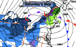
Saturday:
Morning shower, otherwise a mix of clouds and sun. Early morning highs in the 50s, temperatures will drop into the 40s during the day. Windy. West winds increasing 15-30mph with gusts to 40mph.
Tonight:
Partly cloudy. Windy early. Lows around freezing in the City, the 20s inland. West winds at 15-25mph with gusts to 40mph during the evening. Winds will diminish late.
Sunday:
Partly sunny. Rapidly moving midday snow showers or a snow squall. Seasonable. Highs upper 30s.
MLK Day:
Partly sunny. Cold. Highs in the lower 30s.
Tuesday:
Low to moderate potential of some snow. Highs around 30º.
Wednesday:
Partly sunny. Cold. Highs in the upper 20s.