Synopsis:
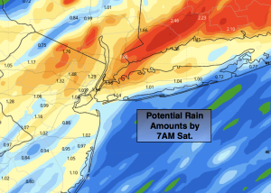
A storm will affect the region tonight into early Saturday morning with rain. Amazingly this storm will take the same track as its predecessor. An inland track meaning rain once again. The rain will develop between 7pm and 10pm. The brunt of the storm will be between 11pm and 5am. The thinking is it will not be nearly as severe as the last storm. 1/2 inches to 1 1/2 inches of rain is possible and winds will be gusty. A Flood Watch has been posted for areas North and West of the City. Flooding will once again be a concern as rivers and streams are high or at flood stage. Winds will gust out of the Southeast between 40-55mph with the highest gusts being at the coast. A few trees may topple do to the completely saturated soil and strong gusts.
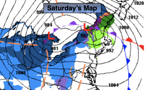
Rain over Eastern sections will end around sunrise Saturday. The wind will diminish rapidly throughout the region in the early morning, but then pick up dramatically later in the morning out of the West as a cool front moves through with scattered showers. Temperatures will start off mild around sunrise and drop throughout the day as a cool front pushes offshore.
Sunday will be the tranquil weekend day with abundant sunshine and seasonable readings as Canadian air settles upon the region. Average highs are in the upper 30s.
The Reverend Dr. Martin Luther King Jr. Day will be bright and cold with highs near freezing.
The extended computer guidance continues to develop a low off the Southeast coast on Tuesday. The track of the low is yet to be determined. As of this writing there is a low to moderate potential of some snow.
Wednesday will feature partly sunny skies and coldest temperatures of the season so far. Highs will remain in the mid and upper 20s.
Stay tuned.
Keep it here for a no nonsense, no hype forecast.
Tonight:
Rain. Windy. Mild. Temperatures rising into the 50s late, the 40s inland. Southeast winds at 15-25mph with gusts between 40-55mph. Highest gusts will be at the coast.
Saturday:
Morning shower, otherwise a mix of clouds and sun. Early morning highs in the 50s, temperatures will drop into the 40s during the day. Windy. West winds at 15-30mph with gusts between 40-50mph.
Sunday:
Partly sunny. Cold. Highs in the mid to upper 30s.
MLK Day:
Partly sunny. Cold. Highs in the lower 30s.
Tuesday:
Low to moderate potential of some snow. Highs around 30º.
Wednesday:
Partly sunny. Cold. Highs in the upper 20s.