Synopsis:
The significant storm that gave the area heavy rains and high winds last night will pull into Southern Canada today. A mix of sun and clouds is expected with a spotty shower possible. It’ll be windy. High temperatures will have occurred during the wee hours of the morning then drop some during the day.
High pressure will move in for the end of the week. Temperatures will remain above the average high of the upper 30s under a mix of sun and clouds.
The next system will affect the region Friday night into Saturday morning with rain. Amazingly this storm will take the same track as its predecessor. An inland track meaning rain once again. The rain will end during the morning Saturday ands skies will break for sun. It’ll be windy. Temperatures will start off mild and drop through the day.
Sunday will be the tranquil weekend day with abundant sunshine and chilly readings as Canadian air settles upon the region.
Stay tuned.
Keep it here for a no nonsense, no hype forecast.
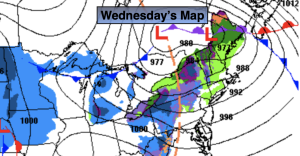
Wednesday:
Partly cloudy. Windy. A spot shower possible. An early morning high of the lower to mid 50s, temperatures will drop into the 40s during the day. West winds at 15-30mph with gusts to 45-50mph.
Tonight:
Mostly clear. Breezy. Lows in the mid 30s in the City, around 30º inland. West winds at 10-20mph with gusts to 30mph. Winds will diminish late.
Thursday:
Partly sunny. Highs in the mid 40s.
Friday:
Sun to clouds. Highs in the mid 40s.
Saturday:
Morning rain, otherwise partly sunny. Early morning highs in the 50s, temperatures will drop into the 40s during the day.
Sunday:
Partly sunny. Cold. Highs in the 30s.