
Synopsis:
A storm will develop over the Southeast today. Clouds will thicken during the morning and snow or rain will develop between 3 and 6pm from Southwest to Northeast. The I-95 corridor looks to be the rain/snow line between for the beginning of this event.
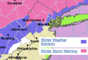
Significant snow is likely North and West of the City tonight. Winter Storm Warnings have been posted (map above). It has been a couple of years since much of our region has had significant snow.
There will be only marginally cold air to work with as the low moves up and along our coast. Ocean water temperatures are in the upper 40s. This all translates to a difficult chore in keeping snow as the main precipitation type over much of the coast and the I-95 corridor. A slushy coating is possible along the corridor, then rain is expected. There looks to be a good thump of snow at the onset for many inland regions just North and West of I-95 this evening. A couple of inches may fall in a short period of time. Then a mix is expected. Inland, it will be just cold enough for the heavy snow potential. Several inches to close to a foot may fall. The last call snow map is above. Inland areas may see a mix as the heaviest precipitation moves out later tonight.
The low will move South of Eastern Long Island to near Cape Cod on Sunday. Clouds will linger and an intermittent light mix of snow and rain is possible. Temperatures will be marginal for an accumulating snow in most areas with the exception being regions to the North. Maybe an inch or two at most.
High pressure will move in on Monday bringing with it the sun.
A significant storm will affect the area later Tuesday into Wednesday morning. Heavy rain, high winds and balmy temperatures are anticipated.
Stay tuned.
Keep it here for a no nonsense, no hype forecast.
Saturday:
Thickening clouds. Late day light snow or rain. Highs in the upper 30s. East winds at 8-12mph.
Tonight:
Snow, mix or rain depending on location. Lows in the mid 30s in the City, around freezing inland. East to Northeast winds at 10-20mph with gusts to 30mph at the coast.
Sunday:
Chance of light snow. Mix to the South and East. Highs in the upper 30s.
Monday:
Sunny. Highs around 40º.
Tuesday:
Increasing clouds. Rain developing during the afternoon. Milder. Highs in the mid 50s.
Wednesday:
Morning rain becoming partly sunny. Windy. Mild. Highs in the mid 50s.