Synopsis:
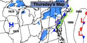
A storm will develop off the Carolina coast and move out to sea today. The clouds and sun will battle it out but the sun will win out as the day continues. It’ll be come breezy as a cold front sweeps through and the storm intensifies well out to sea.
Cold high pressure will influence our area on Friday. It’ll be bright with a nip in the air.
A storm will develop along the Gulf coast on Saturday. Morning sun will give way to increasing clouds. Light snow or rain will possibly develop later in the day. The I-95 corridor looks to be the rain/snow line between for the beginning of this event.
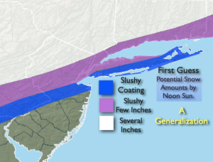
The potential is there for an accumulating snow for inland and Northwestern regions Saturday night into Sunday. It has been a couple of years since much of our region has had significant snow.
As of this writing it looks like there will be only marginally cold air to work with as the low moves up and along our coast. Ocean water temperatures are in the upper 40s. This all translates to a difficult chore in keeping snow as the main precipitation type over much of the coast and to the South of the City. Inland, the potential for several inches of snow exists. The first guess snow map, a generalization of what may transpire is above. This map will get updated several more times until the event nears Saturday night and Sunday morning.
Stay tuned.
Keep it here for a no nonsense, no hype forecast.
Thursday:
Clouds and sun in the morning. Becoming sunny and breezy. Highs in the lower 40s. Increasing Northwest winds at 15-25mph.
Tonight:
Clear and cold. Lows in the mid 20s in the City, the teens inland. Northwest winds 10-20mph.
Friday:
Sunny. Colder. Highs in the upper 30s.
Saturday:
Morning sun, otherwise increasing clouds. Chance of late day light snow or rain. Highs around 40º.
Sunday:
Chance of snow. Mix to the South and East. Some afternoon sun possible. Highs in the upper 30s.
Monday:
Sunny. Highs around 40º.