Synopsis:
High pressure will dominate our region today and Wednesday. Abundant sunhine and just above average temperatures are anticipated. The average high is around 40º.
A storm will develop off the Carolina coast and move out to sea Thursday. No precipitation is expected although clouds will filter our sky. The sun will dominate by afternoon.
Cold high pressure will influence our area on Friday. It’ll be bright with a nip in the air.
A storm will develop along the Gulf coast on Saturday. Morning sun will give way to increasing clouds. Light snow or rain will possibly develop later in the day. The I-95 corridor looks to be the rain/snow line between for the beginning of this event.
The potential is there for an accumulating snow for parts of the region Saturday night into Sunday. The signal continues to be there. It has been a couple of years since significant snowfall threatened much of our region.
Stay tuned.
Keep it here for a no nonsense, no hype forecast.
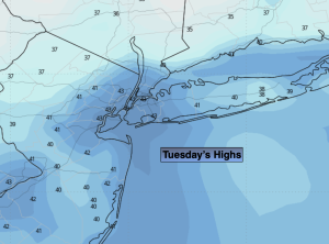
Tuesday:
Mostly sunny. Highs in the lower to mid 40s. Northwest winds at 5-10mph.
Tonight:
Clear. Lows in the mid 30s in the City, the 20s & 30s inland. West winds 5mph.
Wednesday:
Mostly sunny. Highs in the lower to mid 40s.
Thursday:
Clouds and sun. Highs around 40º.
Friday:
Sunny. Colder. Highs in the upper 30s.
Saturday:
Morning sun, otherwise increasing clouds. Chance of late day light snow or rain. Highs around 40º.