Synopsis:
A weak disturbance will move toward the region for New Year’s Eve. A passing flurry or sprinkle can’t be ruled out at the stroke of midnight as we ring in 2024. Readings in most areas will remain above freezing until morning.
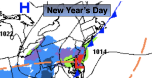
An isolated sprinkle of flurry is possible New Year’s morning as the disturbance moves off the coast. If we’re lucky the sun may shine in the afternoon. Highs for January 1st will be in the mid 40s. The average high is around 40º.
High pressure will dominate our region on Tuesday and Wednesday with abundant sunhine and just above average temperatures.
A storm will develop over the Southeast and move off the coast on Thursday. No precipitation is expected although some clouds may filter our sky.
Cold high pressure will influence our area on Friday. It’ll be bright with a nip in the air.
Stay tuned.
Keep it here for a no nonsense, no hype forecast.
Tonight:
Mostly cloudy. Spotty sprinkles or flurries. Lows in the mid 30s in the City, the 20s & 30s inland. North winds 5mph.
New Year’s Day:
Spotty morning sprinkle or flurry, otherwise more clouds than sun. Highs in the mid 40s.
Tuesday:
Mostly sunny. Highs in the mid 40s.
Wednesday:
Mostly sunny. Highs in the mid 40s.
Thursday:
Mostly cloudy. Highs in the lower 40s.
Friday:
Sunny. Colder. Highs in the upper 30s.