Synopsis:
It’ll be mainly cloudy through Christmas Day as a weak disturbance makes a visit. Spotty showers are possible tonight into Christmas Eve day but much of the time will be dry. Readings will moderate from near seasonable levels today (the lower 40s) to milder temperatures Sunday and Christmas Day. Offshore high pressure will be responsible for our warmup.
The mild streak will continue though midweek with rain returning on Wednesday.
Stay tuned.
Keep it here for a no nonsense, no hype forecast.
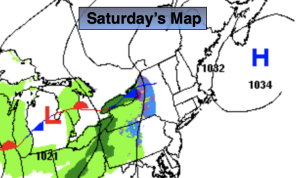
Saturday:
Mostly cloudy. Highs in the lower 40s. Southeast winds at 5mph.
Tonight:
Mostly cloudy. Spotty showers. Lows around 40º in the City, the 30s inland. Light Southeast wind.
Christmas Eve:
Mostly cloudy. Spot showers. Milder. Highs in the upper 40s.
Christmas Day:
Mostly cloudy. Mild. Highs in the lower 50s.
Tuesday:
Mostly cloudy. Highs in the lower 50s.
Wednesday:
Rain. Mild. Highs in the mid 50s.