Synopsis:
It’ll be Tranquil times the next several days as we head into the weekend and Christmas Day. The only threat of a few showers will come Saturday night with a weak disturbance passing through otherwise high pressure will dominate.
Today will be bright and chilly with Canadian air paying us a visit. Saturday will be more seasonable under a mix of sun and clouds. By the Christmas Eve and Christmas Day a Southwest flow will develop around offshore high pressure. Readings will move to above average levels. It will be mild. Another Christmas that won’t be white. At least it won’t be freezing cold!
The mild streak will continue into Tuesday.
Stay tuned.
Keep it here for a no nonsense, no hype forecast.
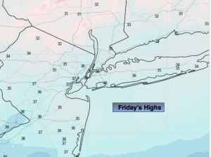
Friday:
Mostly sunny. Chilly. Highs in the upper 30s. Northeast winds at 5mph.
Tonight:
Mostly clear. Cold. Lows around freezing in the City, the upper teens and 20s inland. Light Southeast wind.
Saturday:
Partly sunny. Highs in the lower 40s.
Christmas Eve:
Clouds to sun. Milder. Highs in the upper 40s.
Christmas Day:
Mostly sunny. Mild. Highs in the lower 50s.
Tuesday:
Mostly cloudy. Mild. Highs in the lower 50s.